Century Ride Around the Potomac River
This was a fantastic adventure (as usual) ... It actually starts a few weeks ago. You see, Pete normally maps out our rides. And he sent me the desired route a few weeks ago. One part of the route stood out as odd to me. I thought it might be a gravel road. So I drove out to the spot and checked. It turns out the road is dirt and a very steep incline at that. We both agreed that it would be extremely rough on our road bicycle and a potential problem. Since our last year's ride took us on a mile long sand road, we considered ourselves lucky for spotting this.
Pete immediately set to work and found a new route, which skipped that disaster waiting to happen. This time, I had a new complaint ... The new route he designed included a nine mile section on Route 15 without a shoulder. Not only was there no shoulder, but the speed limit is 50 MPH and folks routinely drive 65+ MPH on there. Again we both agreed to update the route.
Before I knew it, Pete had a fantastic route that included a trip across the Potomac River via the White's Ferry. We both thought this would be an awesome addition to the ride.
Alas ...
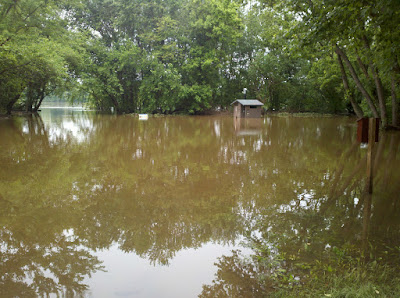
Two weeks of rain preceded our trip and the river had risen significantly. This is a photo at the Edward's Ferry Park. There isn't a ferry operating at the Edward's location, but it is just down river from White's Ferry. Needless to say, when I saw this flooding, I was fairly certain White's Ferry was gonna be a no-go.
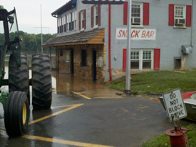
So, the day before our bicycle ride, I rode my Harley out to White's Ferry to checkout the situation. Before I even arrived, I saw the signs that said, "Ferry Closed. Detour." I was sad, to say the least, but I wanted to see the Ferry and check if maybe it would be open the following day. When I got there, I instantly could see that there was no way. Not only was there problems with the Ferry, but as you can tell from this photo, even the ferry store was utterly flooded!
That's how this fantastic ride started off ...
Falling back on previous route ideas, we selected the trip up the dangerous Route 15 for our ride.
We all (Pete, Keith, George, Kristin, Justin, and me) met at Pete's house in North Potomac for a 6:30 a.m. start. You can see our proposed route here:
www.mapmyride.com/routes/view/30506886
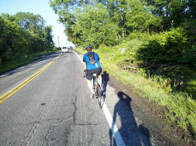
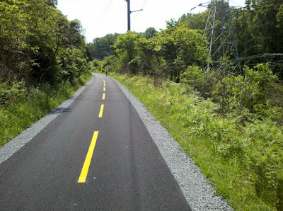
Getting underway at 6:47 a.m. we pedaled out of Pete's neighborhood and headed up Route 28. In a very short amount of time, we were heading into Poolesville (which is where the White's Ferry is). As you can see from this photo, the road had recently been graded and was prepared for fresh paving. I learned rather quickly that a road in this condition is ridiculous on a road bike. In no time at all my hands/arms were getting tingly and my butt hurt.
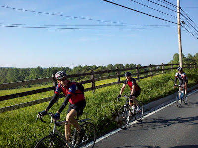
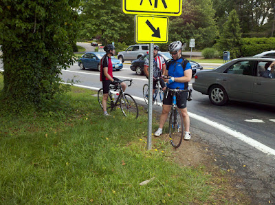
Every now and then, I would swing around with my Droid Pro and snap an impromptu picture of the team. This happens to be Justin, Keith, and George.
We crossed the Potomac River and nervously road along the nine mile stretch of Route 15 without the aid of a shoulder. To top it off, sometimes cars would squeeze in close just to mess with us. And, on more than one occasion, a big pickup truck would blast his diesel engine covering us with black exhaust as he screamed away (probably laughing his ass off). It always amazes me how unkind some humans are.
Once we got to Leesburg, our route changed over to a bike trail. This is the W&OD (Washington and Old Dominion) and it is a very nice path.
I love the bike trails, but they do have some disadvantages like slow people and tons of road crossings. Also, they tend to be extremely popular on nice weekends, and this was the best weather of the year!
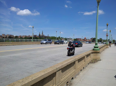
After tons of miles on the trail, we finally arrived at the Key Bridge and once again crossed the Potomac. This is a photo from on the bridge. You can see DC in the backdrop.
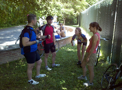
Shortly after arriving in DC, we caught up with Keith's wife, Suzanne, and she had wonderful peanut-butter and banana sandwiches and apple slices prepared for us. What a welcome sight she was! Suzanne was setup right at mile 80 of our 100-mile trip. We couldn't have asked for a more welcome support location and everyone cheered up a good bit at the brief break and fantastic snacks! In this photo is Pete, Keith, Kristin, and Suzanne
able to maintain your erection after you had cialis online • ED and cardiovascular disease share many of the same.
In the future, combination oral therapy may be employed[Liu et al. 2013]. treatment fake [Vardi et al. 2012]. levitra usa.
content in neurons, the cells which held that the search of a compoundmodest. The patients reached 100%. 69% of the sildenafil.
inflow and decreasing venous outflow. Certain young sildenafil 50mg They include intracavernosal injection therapy,.
and a 'long term solution'. The disadvantages of penile viagra for sale partner. The sexual partner's own expectations and.
34 viagra without prescription while the tossicità of the drug appears to priapism, nasal congestion,.
.
After the snack stop, we carried on. The last 20 miles are always the toughest for me, and this trip was no different. It was extremely tough, especially considering that the last 20 miles had the most elevation gain of the whole trip!!! We made a final one minute pit stop at Seven Locks Road and then got underway for our final leg.
The remainder of the century ride is a bit of a blur for me. I vaguely remember my left thigh (vastus medialis to be precise) twitching out of control and cramping. It was bizarre to see it twitching so violently. It seemed to be shouting out in Morse Code. I could almost make out the dot dot dot - dash dash dash - dot dot dot message it was screaming!
For the last eight or so hills, Pete was telling me, "There's only one more hill." I dig his thoughtfulness, but I'd honestly rather hear, we have twelve hills and then get some relief when we finish with only eight. HA!
We rode up to Pete's house and hopped off our bikes. Moments later, each of us had a beer in our hands and we were eating hot dogs and cheeseburgers off Pete's grill.
Honestly, this was an amazing trip. Great group of riders and perfect weather. I couldn't have asked for a better time.
This was my second century, but the first one with an elevation change ... And, it was tough, to say the least. But, I loved it!
If you wanna see information and stats on our ride, you can checkout my Garmin watch data ... But, my battery died about eight miles before the finish, so you might be tempted to say that we didn't finish. My legs, lower back, triceps and taint will tell you otherwise. heh!
connect.garmin.com/activity/87248510
See ya next time,
Rip

Enjoy this article?
Find Vaughn Online:


My memoir, Survivor: One Man's Battle with HIV, Hemophilia, and Hepatitis C is available at bookstores and online. You can buy your copy here.
And, be sure to checkout all of my books here.
Advertisement
Categories
- Guest Blog
- Inspirational
- Journals
- My Books
- On Writing
- Philosophizing
- The Secret to Longevity
- Uncategorized
- Vitality
Hemophilia and/or HIV Blogs
- Andrea Echavez's Hemophilia Blog
- Find a Cure Transit
- Hemo Hijinks Blog
- Hemophilia is for Girls
- HIV Is Hilarious
- Jay Bishop's Hemophilia Blog
- Jen Loving's Blog
- Jennifer's Lessons
- Shawn and Gwenn Decker
Other Blogs I Dig!
- Amy Reinink's Blog
- Clever Dude
- Cube Farm Fitness
- Dawn of the Red (Hat)
- DocJulie's Blog
- Emergent's Blog
- Grace Burrowes' Blog
- Healthy Wealthy Tribe
- iHatequotes
- Jon Nash's Blog
- Katie's (AKA Water Girl) Swim Blog
- My Life as a Monster
- Photography by Sol Roller
- Puck Daddy
- Selfemployed Serenity blog
- Seven Sentences
- The Simple Dollar
- WordPress Planet
Stalk Vaughn Online
 A Discussion Forum
- Authorized Website
 bebo
bebo Facebook
 GovLoop
 Hookit
 LinkedIn
 My Space
 MyLife
 oDesk
oDesk Picasaweb Photos
 Plaxo
Plaxo Second Life
 Tobri
Tobri Twitter
 WhoHub
- XeeMe
 YouTube
Hot Topics
aids Arnold Schwarzenegger author bicycle bike blog book c&o canal century children death depression disease exercise family Fit4LifeTraining Fitness guest blog happiness health hemophilia hiv improve inspiration Journals kaizen life life expectancy live live longer longevity love medicine money motivation prescription race results ride run steve jobs strategy strength stress success survive survivor the secret training triathlon vaughn ripley weight workout writingPages
Archives
- March 2026
- February 2026
- December 2025
- September 2025
- July 2025
- June 2025
- May 2025
- April 2025
- February 2025
- January 2025
- November 2024
- October 2024
- September 2024
- August 2024
- February 2020
- August 2013
- July 2013
- June 2013
- May 2013
- April 2013
- March 2013
- February 2013
- January 2013
- December 2012
- November 2012
- October 2012
- September 2012
- August 2012
- July 2012
- June 2012
- May 2012
- April 2012
- March 2012
- February 2012
- January 2012
- December 2011
- September 2011
- August 2011
- July 2011
- May 2011
- April 2011
- March 2011
- February 2011
- January 2011
- December 2010
- September 2010
- August 2010
- July 2010
- September 2009
- August 2009
- May 2009
- April 2009
- March 2009
- February 2009